Wednesday, July 3, 2024
Partly Cloudy, 77°Wind: mph,

Welcome to our new web site!
To give our readers a chance to experience all that our new website has to offer, we have made all content freely avaiable, through October 1, 2018.
During this time, print and digital subscribers will not need to log in to view our stories or e-editions.
The Las Cruces City Council approved a planning document Monday that sets the stage for potential development on Northrise Drive.
The Northrise Blueprint was approved on a 5-to-1 vote on Feb. 5, after receiving unanimous approval from the Planning and Zoning Commission on Dec. 19, 2023.
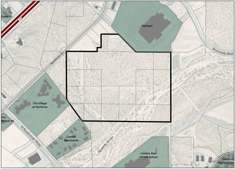
The plan calls for new roadways for an anticipated suburban development in the currently vacant plots wedged between the Rinconada Boulevard Walmart to the northeast, Northrise Drive to the northwest, North Roadrunner Parkway to the southeast and Camino Real Middle School and Alameda Arroyo to the southwest. The area is about 62 acres.
“We started to see a variety of people asking to come in and develop it,” David Weir, deputy director of community planning, told the Planning and Zoning Commission on Dec. 19, according to meeting minutes. “There was limited access to it. And so, we wanted to get ahead of the proposals coming in.”
At the same meeting, Weir said the Blueprint’s primary goal was to ensure the parcels had access to nearby roadways in the landlocked area, which already has utilities.
“The second goal was that any of those transportation networks address all modes of transportation whether that’s pedestrian, biking, transit or, again, vehicle use,” Weir said, adding that preserving or “honoring” the arroyo was the third goal of the plan.
The city defines a community planning blueprint as a document facilitating development in a given area. It outlines goals, challenges and other details to support “planned and orderly development,” as stated in the Northrise Blueprint.
The area is zoned mostly as ranch and farmland, with one portion demarcated for multifamily housing, such as apartments. That’s likely to change as private companies seek to develop the land.
According to documents attached to the proposal, a large swath of the southeast area is also in a flood plain created around the Alameda Arroyo. Weir said that building in a flood plain requires additional permitting and more intensive development, but city officials also suggested the area might be better suited as preserved open space.
Flooding was the topic of one councilor’s concerns.
Yvonne Flores, representing District 6 which includes the area of potential development, expressed concern that future homes in the area could be impacted by a flash flood.
“Everyone seems to think, ‘Oh, these floods only happen once in a blue moon,’” Flores said, “but if that blue moon happens to be me, I’m going to care about it.”
She asked if the city had taken any steps to ensure the safety of future homes built in the area.
Weir said the Northrise Blueprint would help since it would be a reference point for any zoning changes before development.
“Those more detailed flood analyses take place when there’s an actual subdivision or a building permit for that area,” Weir said.
Flores wasn’t convinced. She reiterated her concern for potential flooding in the future before voting against the plan.
“When the time comes for development, I just hope that the city does keep an eye on that,” Flores said before voting against the plan.
Most of the land in the area is owned through the trust of Gerald Lee Lackey, a Hatch car dealership owner who passed away in 2023. Other notable owners include Lonesome Dove Land, Pioneer Construction and the St. Andrews Protestant Episcopal Church (whose land makes up much of the flood plain).
The Northrise Blueprint also abuts land owned by Walmart, the New Mexico State University Foundation, the New Mexico Land Office and the homeowner’s association of The Pueblos at Alameda Ranch.


